
Tags
As a kid, like many other kids, I was fascinated by time travel. And perplexed. If I could go back in time and cause my grandfather’s eye to fall on someone other than my grandmother, would I be? That is, would the I which had gone back in time even exist, and if not exist not be able to interrupt the romance, and so exist? Endless long summer evenings with stars squinting down from the infinite onto my grandfather’s eyes in me were spent in wrestling with such questions.
Little did I realize that I was time traveling even as I pondered, looking at light that had departed its source star thousand and millions of years before. In fact, some of the stars I took as “being there” had likely run their starry course and were no more; we just wouldn’t know until its last ray reached our eyes.
I had also been time traveling all that day, and would be the next, and for many summers, along with scouts, family or hiking buddies from teen-age years. Not as mesmerizing as the stars, but the stones underfoot are more present. We can touch them, jump from Age to Age (millions of years) in a single day or take in an Era (tens to hundreds of millions of years) in a sweep of the eye. This basalt pile came into existence 350,000,000 years ago, that scratch on the smooth outcrop and the ankle turning shards below it only 12,000 years ago, though of course the mother stone had become millions of years prior.

Pillow Lava, formed deep under water, high in the Sierras
I returned to time travelling recently with a hiking group of 13, led by Bay Area naturalist, Michael Ellis [Footloose Forays] to the Lakes Basin region of the northern Sierras. Now I keep a walking stick in each hand; time travel is tough. It’s easy to get dizzy stepping along the trail as he points out yesterday’s blooms– though their ancestors appeared, oh, 120,000,000 years ago (that’s 120 million years ago –mya. On a map of the universe as a year, from its beginning to today (the last nano-second before midnight on December 31st) and 130 million years ago is the 28th of December! Humans came to North America on Dec 31, 11:59:46 pm; 4 seconds ago.)
A bird (their arrival about 150 mya) plunges through the forest. “Northern Flicker,” calls Michael. A sharp three note sound, no bird in sight. “Olive sided flycatcher,” he says. “And over here is bracken fern.” (400 mya, pre-tree, pre-flower.) We have to hustle, foot and brain.
 Lakes Basin is on the Eastern side of the Pacific Crest Trail, though not yet at the sharp eastern slopes of the range. Find the town of Graegle, north west of Reno, here and you’re in it. Westerly winds blow clouds from the distant Pacific and stir the needles of last fall, yesterday’s dust and this morning’s perfumes onto the tents and drying dishes. Underfoot on many of the trails, and scattered on the slopes, is Pleistocene (most recent ice age) gravel and glacier crushed stone, washed in rain, broken by expanding ice, some ground to finger size over thousands of years, some fallen as big as barrows when the last ice retreated. All of it broken off from much older sandstone, andesite and granite.
The morning’s flowers (angiosperms, that’s ‘covered seed’), goldenrod, poisonous angelicum, fireweed, shoulder the trails as they wind through the 20 plus lakes in the area. Spring came early this year, as it has been lately in this Anthropocene Epoch, and we are seeing more end-of-season dead heads than we had hoped. The corn lillies, are all but gone, leaving only their large green enclosing leaves. Conifer trees (gymnosperm, that’s ‘naked seed’, and say, oh, 350 million years of evolution), white and red firs, lodgepole and yellow pines, incense cedars, provide occasional shade, subtle perfumes for the nose and tongue, and softer trails for aching feet. Under some of the trees are the wonderfully strange, red-purple pinedrops. With no ability to produce chlorophyll (they have no green) they draw their growth energy from fungi found on the roots of the trees they congregate under.

Pinedrops
Ω
Thinking about mountain formation you have to hold several things in your mind. For mountains to rise, something has to exist to be raised up. So if “when were the Sierras made ?” is the question we have to ask another. Do you mean “when was the material which became the Sierras laid down over an old ocean floor?” Or, “when did that material actually begin to rise?” There is a third question as well since, in the Sierras especially, the granite we take as synonymous with the mountains, actually came along say, midway though the rising, pushing into the rising mass of former sea-floor, like a slow moving comet from below, solidifying, pushing and finally coming to rest beneath thousands of feet of risen earth. Eventually, that overlying earth, being softer, eroded away, falling in rockslides, weathered into sand, rolling down creeks and rivers to the sea — beginning to lay down sediment which may, down the millennia, be pushed into our existing coasts, or pushed up in a new chain of hills or mountains.

Grand Canyon’s three sets of rocks: lithology, age and thickness.
Time-in-stone is not laid out as nicely here in the Sierras as it is in the Grand Canyon, where floating down the Colorado you cut through, as through a multi-layered cake, to the oldest Vishnu Schist (1.5 billion years ago), the bottom, at mile 84. Even so regular a series still has mystery. Big middle layers are missing as though a Pantagruelian tramp had reached in and pulled them away just as Mother Nature was placing the next layer on the cake. The Sierras aren’t so nicely stacked. It is as if the cake had been twice baked, hardened, dropped, broken, pushed into a pile against the baseboard of the continent and left for some dogged geologists to figure out which layer came in which order.
Where we are now somewhere near Deer Lake, was once ocean floor, say 800 mya, drifted and settled from continental land forms. Then, about 400 mya, during the Antler building event, as tectonic plates rode into each other it was mashed into the then North American coast, about where western Nevada is now. That mashup is now called “shoe fly terrain,” and pretty much what the Lakes Basin is. The coming-into-being continent was much further east and south and rotated clockwise than it is now — the equator running though say Los Angeles to north-central North Dakota.

[A great animation of North America
over the past 600 million years.]
It’s not yet clear to geologists what brought about the Antler orogeny — plate techtonics surely, but what pushed against, subducted under or rode up over is not yet clear. Underneath the crustal land movement, powered by the immense volcanic fires, blobs of melted stone rose. Imagine enormous, rising, viscous bubbles, say from 245 – 65 mya. If it cooled while still covered with mountain, because of physical and chemical reactions, it became granite. Later the mountains, yielding to rain and wind and gravity shed its softer outer layers, revealing the long buried granite, from 70 – 20 mya. Apparently the Sierra granite batholith, is a long ovoid, a blimp as John McPhee calls it, pushed higher in the southern sierras, and so more revealed, and still below earth in the north…
If the rising magma did not cool beneath the earth but broke into air or water, it became something else; if in the air, black volcanic basalt, or gray-green andestite, if under water, pillow basalt. And as it turns out, one of our major destinations, the Sierra Buttes, was a mix of all. Shoved along in the Antler orogeny, some 360 mya, (you remember, before flowers (angiosperm_ ) before conifers (gymnosperm), after ferns, and still standing at 8785 feet above sea level, its hard lava stone more impervious to weathering than the surrounding area.
But wait! We still don’t have today’s Sierras, which didn’t begin to assume their present shape until 20 or fewer mya. Several other “orogenies” followed the Antler. The Sonoma and Nevada “events” (millions of years each) pressed more island arcs against the rotating continent; more volcanics erupted 50 miles or so inland from the coastal collisions. After some time off, the North American west started stretching from east to west, fracturing into north-south fault lines. As the eastern edge of each section rose, the western fell, like enormous truck ramps. The “Basin and Range Province” was formed, extending from central New Mexico to the eastern slopes of the Sierra Nevada, from southern Oregon deep into Mexico [an image here] Flying over the area we can see hundreds of “caterpillar” like formations showing the lifted eastern ranges. The far western edge of the Basin and Range is the steep eastern slope of the Sierras, lifted like all the others, though much higher, and falling away gently to the west. So the answer to ‘When did the Sierras rise?’, is from about 20 mya (some have it 4-5 mya) to today — and still rising, about as fast as they are eroding away. But the stuff of which they are made, the dirt we are walking on, has a traceable ancestry to about 800 mya, when multicellular creatures were beginning to split and sponges to appear, the 14th of December in our Universe in a Year. Life as we think of it still had 200 million years to go, fish appearing about 600 mya, the 17th of December.
On day three, the Sierra Buttes were our destination, 1,500 feet of elevation increase and 365 million years into the past. It was our toughest day. We climbed the 1,500 feet over a distance of about 2 miles (10,000 feet,) a gradient of about 15%, steep in anybody’s book. And that’s just the average. Some places the trail descended so that decrease had to be recovered, some places were flat and didn’t help the ascent. The rest made up for it, often, my guess, a 20 – 25% grade. The last 50 feet were up steel stairs which, if expressed as a gradient would be 60%. It was a test for all, some more than others, and self imposed. We passed it, all, some troubled by heights, some by the heat (though 20° cooler than below,) some by lack of oxygen (about 85% of that at sea level) and others by sheer fatigue. Some brats were not troubled at all of course, hula-hooping on a flat stone at 8785 feet while the others gathered themselves, to re-hydrate and appreciate the enormity of the distances falling away from us.
On the way back the group drifts into familiar constellations. Up in the lead the pushers: faster is better. A few separate off to walk in silence, letting the trail direct their thoughts as well as feet. Further behind, respectfully keeping their distance, come the talkers, walking in a pleasant mist of conversation: no opportunity for a good chat should ever be wasted. Back in the rear are those who stop to set up photos, of ferns or flowers, or who, like me fall into a fine trail meditation: not emptying the mind, but directing it down at the stone beneath my boots, traveling the millennia one step at a time
Nearing camp it is utterly still, not even the aspen leaves are twitching. The sky is sere and blue. Even though the coming down is less difficult that the going up, day-packs and head bands gather sweat. A small pillow of cloud drifting over the crests promises a softer evening. Through a cool space of trees laughter sounds, of angels it seems, water running over stone in a small, rare stream.
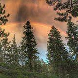
As evening whispers in, only the jays break the silence, jumping from branch to bough shrieking admonitions like soap-box preachers at Speakers Corner. A hummingbird briefly investigates the red Tibetan prayer flag and zips off into invisibility. A dinner teams cuts and slices, turns up the gas under pans and griddles, the menu secret until the moment of revelation. We sit and sip cold beer, coconut water and even chilled wine, counting the steps of the day, reviewing yellow plants we’ve seen, misremembering the names of birds. One brings out a guitar and tunes it, tests the strings, puts it aside as the promise of rain drifts through. A rainbow assures us there is water up there somewhere. We count about 301 drops.
The night grows dark, the moon comes up, the fire leads us off to memory or to song.
Appendix
If you know something about continental drift and the crazy super-glued terrain of California it is most likely through John McPhee’s wonderful quintet of books on geology and geologists. The most relevant for us is Assembling California, the fourth in the series and unhappily, perhaps the most difficult for those with no background. By the time he wrote it in 1993, he’d been working with geology since 1981 and Basin and Range, and no longer needed to clarify for himself certain terms and ideas as he had early on. So the reader, in the opening chapters of Assembling California, is left to puzzle out “phyllites,” “ophiolites,” “temporal stratigraphic gaps,” or “brecciated mudflows.” If you’ve grown up as a reader always looking up new words, then no problem, otherwise, problem.
He does his usual fine job of telling stories and creating analogies, so an old attic stuffed with furniture from many historical periods helps us imagine the work of geologists in sorting out the time and provenance of different stone. He tells of John Sutter and the California gold rush, how the miners located gold and the damage they did when the finding grew difficult. Those stories in turn tell us about the earth that produced it.
Many of our gang at camp had given McPhee a try and some allowed as how Assembling California was the most difficult of the five to enter into. For an easier start, though longer to get to California, perhaps reading them in order, now collected in one large volume, Annals of the Former World, might be best:
- Basin and Range, 1981, The American West, not including California
- In Suspect Terrain, 1983, New York City, the Appalachians
- Rising from the Plains, 1986, The Rocky Mountains
- Assembling California, 1993, California
- Crossing the Craton, 1998 with The Annals of the Former World, the very beginnings.
Another excellent way to begin nosing into the rocks is in the very well done Roadside Geology series. Roadside Geology of California is always in my car; we buy a book for every road trip we make.
Other choices are in the great California Natural History Guides, a mesmerizing list of titles. Doris Sloan’s Geology of the San Francisco Bay Region keeps me company [Here she is an a 2 1/2 minute YouTube trip.] Mary Hill’s Geology of the Sierra Nevada is on its way.
Of course the field is moving fast so there are statements in a book published in 2000 that will no longer be true, a time estimate moving by tens of millions of years for example. By the time you begin to notice such things you’ll already have noticed that one million years is a rounding error in geological time. As McPhee tells us, citing Eldridge Moores, one of the giants of contemporary geology, the most difficult thing for a student to understand is the difference between geological time and human time.
It’s three dimensional imaging in the brain with the fourth dimension, time, being integral. Much better for keeping the synapses tuned and growing than Sunday crosswords or TV game shows.
I loved every step of the way and now understand the complexities of the Sierras. Thanks for taking us along! You’re more readable than McPhee. Took me back to my days scouting Monache Meadows and Olancha Peak just south of there.
We’re planning a stop through at Tuolumne Meadows but a recent report of the plague has it closed down for a while.
Wonderful explanation of time and place — an ‘easier version’ than McPhee’s and with excellent visuals! Michael Ellis should be impressed at how much you took away from that trip! Bravo!
I especially appreciate the references to Universe in a Year–how can one assimilate concepts of the ages without reminding us about when sponges, ferns, fish and humans appeared? The photos: terrific, each and every one. What is so galling is how you can be an expert in so many fields, and a fine teacher to boot: your finest accomplishment, after the challenging hike.
I’m blushing… like a pinedrop!
Grazie mia amore…